Today we took a ride over to the Coronado National Memorial which commemorates the first major European exploration of the American Southwest. The Coronado Expedition, led by Francisco Vasquez de Coronado, left Mexico City in November of 1539 in search of the fabled Seven Cities of Cibola, a treasure of gold. The expedition went as far north as, what is today Salina, Kansas, the supposed location of Quivira. Coronado returned to Mexico City in the spring of 1542 his dreams shattered. He died in obscurity ten years later at the age of 42. Though he never found the Cities of Cibola and he considered his expedition a failure he brought back knowledge of the northern land and its peoples. This knowledge enabled explorers and missionaries to colonize the Southwest and to help develop the distinctive culture we know today.

 |
| One of views on the way to the Visitor Center. |
 |
| Looking out from the front of the Visitor Center. |
While at the visitor center we watched a short presentation about Coronado's Expedition and stamped our National Park Passport. We talked to the woman there and when we asked about the road and if we would be able to continue after leaving the memorial and reach Arizona 82. She told us that not long after leaving the visitor center the road would no longer be paved but it was well maintained with a few switch backs.
 |
| As stated in a short time we saw this sign. |
 |
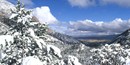
| Some of the views as we made our way to \ the Montezuma Pass Overlook. |
 |
| Some views of the road on the way up. This is a two way road and was pretty much a "washboard". |
 |
| On the left the road ahead. On the right the road behind. |
 |
| The Montezuma Pass Elevation 6575 |
That is a border patrol truck parked behind the sign. There was another similar one across the entrance to the parking area and at least 4 others parked near them.
 |
| Warning to be aware illegal entry and smuggling is common in the area. |
 |
| Titled A Timeless Landscape. Looking West past the sign is the Sain Rafael Valley. The information states it has barely changed since Coronado passed here in 1540-1542. |
 |
| Picture of what is on the left part of above sign. The International Border in the distance. |
 |
| Looking straight out from the sign. |
 |
| Looking to the right of the sign. |
 |
| Standing on the deck area looking East at Montezuma Canyon. |
 |
| Looking Northeast |
 |
| Looking Southeast. |
This is where we sat and ate lunch.
 |
| Our lunch view. |
There was a poster at the visitor center that listed who was on the journey.
This was the list: 700 Indian allies from central Mexico
225 Spaniard horsemen
62 Spaniard foot soldiers
5 Franciscan Priest
Unknown number of slaves, women, and children
4,000 cattle, sheep, and goats
1,500 horses
12 war dogs
The exact number of Europeans on the expedition is known because The Viceroy of New Spain required a detailed list, called a muster roll, of all Europeans who joined. The list also recorded what each soldier brought with them.
The official records tell little about the hundreds of other that marched alongside the soldiers. They were guides, servants, cooks, family members, and slaves.
This was an armed moveable village, snaking its way through mountain passes and river valleys. Each person playing a part in the success or failure of the mission.
It is hard to imagine a force of the size mentioned moving through mountain passes and river valleys. (Though according to what I read they probably did not necessarily come through here. This is a National Memorial commemorating an event not a place.) Plus, according to a sign on the porch, they carried all the vital stores they needed for the expedition plus any tools to keep things in repair along the way. It also mentioned the number of cattle, sheep, and goats to be 6,000. (I wonder which sign is correct?) It was indeed a village on the move.
Before we continued on our way we did take a selfie.

 |
| Just thought the truck deserved a picture. |
Our day's travels continued on the next page.
Did You Know?
The mountain ranges in southeast Arizona where Coronado National Memorial is located are called Sky Islands. They suddenly rise out of the flat desert landscape into the sky, like islands rising above a calm sea.
(from the Coronado National Memorial site)
No comments:
Post a Comment