Note to self: when you are going to visit a National Historic
Site be sure they are open on the days you will be there. As I said in the
17th's post we stopped here to visit the Ft. Bowie National Historic Site and
right now they are closed on Tuesday and Wednesday's.
 |
| Turning off the paved road this is the sign we saw. Plus a lot of prickly pear cactus. |
Following Google Maps we ended up at the Handicap only entrance, did not know this until later when we went down another road and saw the actual entrance to the site.
 |
|
Looked at the picture and sure enough
that is what the sign
said.
|
Anyway, it did save us a mile and a half walk and no one said anything. I am guessing since they were closed it really did not make any difference.
 |
| This was the path looking down, I took these on our way back to the truck, after the stairs it was pretty much up a hill. This was, according to the sign, the handicap entrance. |
 |
| The view of the site from the porch of the Visitor Center. The picture of Ft. Bowie in 1894 was also on the porch. |
In 1868 a less primitive Fort was built on a plateau 300 yards to the southeast. Between 1862 and 1886, Ft. Bowie was the nerve center for military campaigns against hostile Chiricahua Apaches led first by Cochise and then by Geronimo. With Geronimo's final surrender in 1886 this ended both the Apache Wars and Ft. Bowie's military usefulness. It was an active post for eight more years.
When it was abandoned in 1894 Ft. Bowie was a modern post of about 38 structures. These are the ruins we see today. (Information from brochure.)
 |
| Corrals and Stables |
 |
| Quartermaster and Storehouse. |
 |
| Guard House 1886 |
 |
| Another view of ruins. |
 |
| One view from visitor center. |
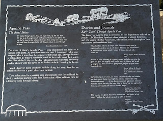
Back to the main road we headed towards Apache Pass and came upon this sign and by this time the road was no longer paved.
 |
| Just after this sign there is a parking area, rest rooms, and information about Ft. Bowie. This is also were the one and half mile trail to the visitor center starts. |
 |
| Before reaching Apache Pass we came upon this sign. |
 |
| Apache Pass |
 |
| The road mentioned in the above information. |
This will definitely be a place we will return to. We would need to arrive earlier in the day and be better prepared for the hike. There is a lot of history here and we hope to explore it further.
"When I was young I walked all over this country,
east and west,
and saw no other people than the Apaches."
~Cochise


No comments:
Post a Comment